Continental shelf
|
|
|

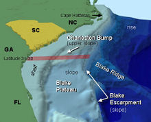
Anatomy of a continental shelf off the south eastern coast of the United States |
|
| Littoral zone | |
| Intertidal zone | |
| Estuaries | |
| Kelp forests | |
| Coral reefs | |
| Ocean banks | |
| Continental shelf | |
| Neritic zone | |
| Straits | |
| Pelagic zone | |
| Oceanic zone | |
| Seamounts | |
| Hydrothermal vents | |
| Cold seeps | |
| Demersal zone | |
| Benthic zone | |
The continental shelf is the extended perimeter of each continent and associated coastal plain, and was part of the continent during the glacial periods, but is undersea during interglacial periods such as the current epoch by relatively shallow seas (known as shelf seas) and gulfs.
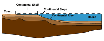
The continental margin, between the continental shelf and the abyssal plain, comprises a steep continental slope followed by the flatter continental rise. Sediment from the continent above cascades down the slope and accumulates as a pile of sediment at the base of the slope, called the continental rise. Extending as far as 500 km from the slope, it consists of thick sediments deposited by turbidity currents from the shelf and slope.[1] The continental rise's gradient is intermediate between the slope and the shelf, on the order of 0.5-1°.[2]
Under the United Nations Convention on the Law of the Sea, the name continental shelf was given a legal definition as the stretch of the seabed adjacent to the shores of a particular country to which it belongs. Such shores are also known as Territorial waters.
Contents |
Geographical distribution

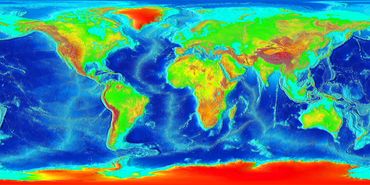
The width of the continental shelf varies considerably – it is not uncommon for an area to have virtually no shelf at all, particularly where the forward edge of an advancing oceanic plate dives beneath continental crust in an offshore subduction zone such as off the coast of Chile or the west coast of Sumatra. The largest shelf – the Siberian Shelf in the Arctic Ocean – stretches to 1500 kilometers (930 miles) in width. The South China Sea lies over another extensive area of continental shelf, the Sunda Shelf, which joins Borneo, Sumatra, and Java to the Asian mainland. Other familiar bodies of water that overlie continental shelves are the North Sea and the Persian Gulf. The average width of continental shelves is about 80 km (50 mi). The depth of the shelf also varies, but is generally limited to water shallower than 150 m (490 ft).[3] The slope of the shelf is usually quite low, on the order of 0.5°; vertical relief is also minimal, at less than 20 m (66 ft).[4]
Though the continental shelf is treated as a physiographic province of the ocean, it is not part of the deep ocean basin proper, but the flooded margins of the continent.[5] Passive continental margins such as most of the Atlantic coasts have wide and shallow shelves, made of thick sedimentary wedges derived from long erosion of a neighboring continent. Active continental margins have narrow, relatively steep shelves, due to frequent earthquakes that move sediment to the deep sea.[6]
Topography

The shelf usually ends at a point of increasing slope[7] (called the shelf break). The sea floor below the break is the continental slope. Below the slope is the continental rise, which finally merges into the deep ocean floor, the abyssal plain. The continental shelf and the slope are part of the continental margin.
The shelf area is commonly subdivided into the inner continental shelf, mid continental shelf, and outer continental shelf, each with their specific geomorphology and marine biology.
The character of the shelf changes dramatically at the shelf break, where the continental slope begins. With a few exceptions, the shelf break is located at a remarkably uniform depth of roughly 140 m (460 ft); this is likely a hallmark of past ice ages, when sea level was lower than it is now.[8]
The continental slope is much steeper than the shelf; the average angle is 3°, but it can be as low as 1° or as high as 10°.[9] The slope is often cut with submarine canyons. The physical mechanisms involved in forming these canyons was not well understood until the 1960s.[10]
Sediments
The continental shelves are covered by terrigenous sediments; that is, those derived from erosion of the continents. However, little of the sediment is from current rivers; some 60-70% of the sediment on the world's shelves is relict sediment, deposited during the last ice age, when sea level was 100–120 m lower than it is now.[11]
Sediments usually become increasingly fine with distance from the coast; sand is limited to shallow, wave-agitated waters, while silt and clays are deposited in quieter, deep water far offshore.[12] These shelf sediments accumulate at an average rate of 30 cm/1000 years, with a range from 15–40 cm.[13] Though slow by human standards, this rate is much faster than that for deep-sea pelagic sediments.
Biota
Combined with the sunlight available in shallow waters, the continental shelves teem with life, compared to the biotic desert of the oceans' abyssal plain. The pelagic (water column) environment of the continental shelf constitutes the neritic zone, and the benthic (sea floor) province of the shelf is the sublittoral zone.[14]
Though the shelves are usually fertile, if anoxic conditions in the sedimentary deposits prevail, the shelves may in geologic time become sources of fossil fuels.
Economic significance
The relatively accessible continental shelf is the best understood part of the ocean floor. Most commercial exploitation from the sea, such as metallic-ore, non-metallic ore, and hydrocarbon extraction, takes place on the continental shelf. Sovereign rights over their continental shelves up to 350 nautical miles from the coast were claimed by the marine nations that signed the Convention on the Continental Shelf drawn up by the UN's International Law Commission in 1958 partly superseded by the 1982 United Nations Convention on the Law of the Sea.[15]
The legal definition of a continental shelf differs significantly from the geological definition. UNCLOS states that the shelf and slope extend to the limit of the continental margin, but no less than 200 nautical miles from the baseline. Thus volcanic islands such as the Canaries, which have no actual continental shelf, nonetheless have a legal continental shelf.
See also
- Baseline
- Continental Island
- Continental shelf pump
- Continental shelf of Russia
- Exclusive economic zone
- International waters
- Land bridge
- Outer Continental Shelf
- Region of Freshwater Influence
- Territorial waters
- Passive margin
Notes
- ↑ Pinet 39, Gross 45.
- ↑ Pinet 37.
- ↑ Pinet, 37.
- ↑ Pinet 36-37.
- ↑ Pinet 35-36.
- ↑ Pinet 90-93.
- ↑ http://www.britannica.com/EBchecked/topic/539632/shelf-break
- ↑ Gross 43.
- ↑ Pinet 36, Gross 43.
- ↑ Pinet 98, Gross 44.
- ↑ Pinet 84-86, Gross 43.
- ↑ Gross 121-22.
- ↑ Gross 127.
- ↑ Pinet 316-17, 418-19.
- ↑ http://untreaty.un.org/ilc/texts/instruments/english/conventions/8_1_1958_continental_shelf.pdf
References
- Gross, Grant M. Oceanography: A View of the Earth. Englewood Cliffs: Prentice-Hall, Inc., 1972. ISBN 0-13-629659-9
- Pinet, Paul R. (1996) Invitation to Oceanography. St. Paul, MN: West Publishing Co., 1996. ISBN 0-7637-2136-0 (3rd ed.)
External links
- Office of Naval Research: Ocean Regions: Continental Margin & Rise
- UNEP Shelf Programme
- Anna Cavnar, Accountability and the Commission on the Limits of the Continental Shelf: Deciding Who Owns the Ocean Floor
|
||||||||||||||||||||||||||||||||||||||||||
|
|||||||||||||||||||


